East Yorkshire coastal erosion
cliffs

it’s not only the sea
at the cliff foot
cliff face
rotational slides
cavities
on the cliff top
Erosion of the glacial tills of the East Riding of Yorkshire is easily and rightly attributed to the action of the sea. But that's not the complete picture. Prolonged periods of wet weather can also be a major agent of cliff erosion.
.jpg)
Saturated cliffs collapse in a wet slump [Atwick: 30 April 2012].
.jpg)
Wet slump [Atwick: 30 April 2012].
.jpg)
Mud flow [Atwick: 30 April 2012].
.jpg)
Rainwater seeps from under a weathered soil surface [Skipsea, Southfield Lane: 26 May 2012].
.jpg)
A wet slump has created a mid-cliff cavity [East Newton: 5 May 2012].
.jpg)
When material slips down a wet cliff face it may leave a slide path [Out Newton: 12 May 2012].
After the rains the dry-out begins, and desiccation. A walk along the beach on a warm day will usually be accompanied by the recurrent sound of fine material trickling down the cliff – with perhaps a sudden fall of heavier material. Winds, especially from the east, also dry the cliffs.
.jpg)
A slide path cracks and breaks up as it dries and shrinks [Mappleton: 26 May 2012].
.jpg)
View down a drying wet slump [Holmpton: 12 May 2012].
.jpg)
A surface made smooth by slipped material or wave-rounding may harden in the sun, though it too cracks [Mappleton: 26 May 2012].
.jpg)
An example of exfoliation [Easington north: 15 October 2011].
Most of the time, however, coastal erosion is certainly the result of the sea eating away at the base of the cliff.
.jpg)
Downdrift (i.e. south) of a major defence work, the cliff line will curve sharply inland to create a bay – see terminal groyne effect. In the right of the picture, a rock armour revetment lies parallel to the water line. An increased rate of erosion has outflanked the defences. Undercutting is evident in the process [Mappleton: 26 May 2012].
.jpg)
Tide at the foot of a cliff [Ulrome: 10 June 2012].
.jpg)
A raised wave-cut notch indicates that beach level has dropped [Atwick: 5 August 2011].
.jpg)
Well-defined cliff ‘toe’ [Withernsea south: 24 September 2011].
.jpg)
Inclined platform, suggesting a gradual lowering of the beach [Dimlington: 24 September 2011].
.jpg)
Berms, or sand steps, are a sign of a more rapid removal of beach [Easington north: 15 October 2011].
.jpg)
Water action produces some unusual shapes at the lower cliff, such as this pendent lobe [Easington north: 15 October 2011].
.jpg)
‘Monster’s foot’ [Atwick: 5 August 2011].
.jpg)
Waves break around a ‘hog's head’ profile [Out Newton: 12 May 2012].
The cliffs continually change in detail even where there might be a semblance of uniformity over distance.
.jpg)
A ‘buttress’ formation [Hilston : 29 September 2012].
.jpg)
Faulted slide [Skipsea Withow: 15 July 2012].
.jpg)
Lateral break [Rolston: 15 September 2012].
.jpg)
Recent blocky fall from a spur [Hollym: 3 September 2012].
.jpg)
Lengthy section of cliff eroded to a serrated configuration, seen from a truncated construction shaft used for the Withernsea wastewater treatment works outfall. The shaft was sunk at the cliff top in 1991 and the shown position indicates cliff recession since then [Hollym: 3 September 2012].
Hollym gallery
.jpg)
Unusual shapes are not confined to the cliff foot. These ‘pantaloon legs’ were undoubtedly formed as a result of material being washed or falling away [Hilston: 29 Sepember 2012].
.jpg)
A Mount Rushmore-like head and face may be discerned (with another directly behind?) [Skipsea south: 26 May 2012].
.jpg)
By way of demonstration of solids being moved around within the clay, two small pieces of stone are shown as found...
.jpg)
...which, when extracted and one inverted over the other, fitted perfectly together [Aldbrough north: 17 September 2012].
.jpg)
An erratic seems to defy gravity. Common alignment within the till of pebbles and stones, as seen in the picture, is a guide to the direction of glacial movement [Atwick: 5 August 2011].
.jpg)
A ‘stringer’ of chalk, which has been crushed and dragged by glacial action [Easington north: 15 October 2011].
.jpg)
Delicate impression of a fossil shell in a lump of fine-grained sediment [Mappleton: 26 May 2012].
.jpg)
A wellington boot, most assuredly a false fossil, would demonstrate a need for care in the interpretation of embedded objects [Dimlington: 3 September 2012].
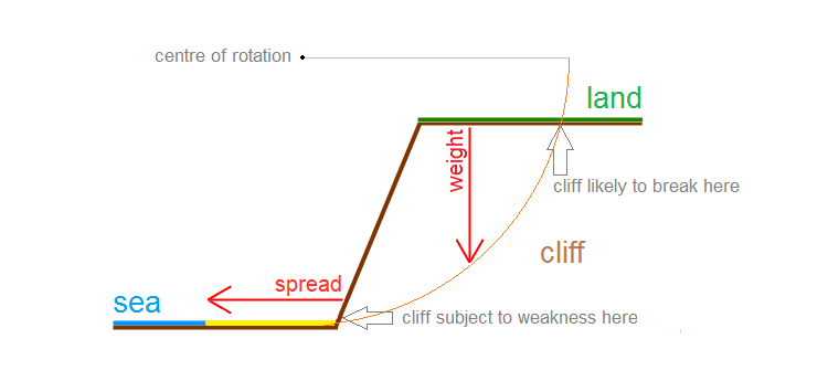
Some cliff collapse in clay material is regarded as conforming to a circular or parabolic movement.
The body of the cliff presses downwards, under the effect of gravity, while the foot of the cliff is free to spread laterally on to the beach. Groundwater within the body increases weight in addition to lubricating internal movement. At the same time, the lower cliff may be weakened by undercutting and removal of material by waves.

There could be more than one arc of rotation present in a slide. An arc need not extend the full height of the cliff face since the clay will break wherever resistance is least. Cliffs often consist of depositional units having different properties.
.jpg)
The most obvious visual characteristic of a rotational slide is a backwards tilt to the section descending the cliff [Skipsea south: 16 April 2012].
.jpg)
Reverse tilt is clearly evident above this slide [East Newton: 5 May 2012].
.jpg)
A pinnacle cluster descends with a marked landwards lean [Rolston: 15 September 2012].
.jpg)
Occasionally, an arc of rotation may be traced in the mind’s eye [Rolston: 15 September 2012].
.jpg)
As the descending section nears beach level, the original land surface reaches maximum tilt. Water may be trapped in the trough that is formed, with sometimes sand and shingle thrown by waves [Aldbrough: 17 September 2012].
Hollows and voids, from dimples to caves, in the soft till are the result of a number of processes.
.jpg)
Taken close to each other at the same till boundary, this and the following picture suggest how a small space might enlarge.
.jpg)
[Dimlington: 3 September 2012].
.jpg)
Clay platform exhibiting localised pitting [Dimlington: 3 September 2012].
.jpg)
Horizontal crevices produced by sagging within the clay [Hilston: 29 September 2012].
.jpg)
Cavities are formed at any angle to the beach line. The arrow points to the sea [East Newton: 10 June 2012].
.jpg)
Muliple cavity formation [Aldbrough: 30 April 2012].
.jpg)
Boulders, perhaps erratics but sometimes lumps of granite plucked from sea defences, become an agent of erosion as tides roll the pieces against the base of the cliff [Withernsea south: 3 September 2012].
The cliff top is where social and economic consequences of coastal erosion are manifest. Plights of owners of domestic and holiday properties are well documented.
Although quality agricultural land is removed each year, the costs of constructing defences may be higher than the value of the loss. Also, protection for one locality is very likely to have a deleterious effect elsewhere.
.jpg)
Farming of the continually reducing land asset is by necessity carried out to the edge [Withernsea south: 3 September 2012].
.jpg)
A late stage in the growing season can provide a clue to the extent of erosion since the crop was planted [Skipsea south: 5 September 2011].
.jpg)
Acquisition of land in the absence of defence works has to be for the shorter term [Hilston: 17 September 2011].
.jpg)
The same is true of commercial investment [Skipsea: 5 August 2011].
.jpg)
Fly-tipping as an instance of environmental abuse [Tunstall: 24 September 2011].
.jpg)
A tranquil pond about to be lost [Holmpton: 12 May 2012].
.jpg)
East Yorkshire’s coastal erosion is often represented by past measurement from the cliff edge...
.jpg)
...some markers being easier to spot than others [Holmpton: 12 May 2012].
.jpg)
Pictures abound of roads that end abruptly... [Skipsea south: 16 April 2012].
.jpg)
...and tracks that lead off the edge [Holmpton: 12 May 2012].
.jpg)
A route no longer available [Hilston: 2 May 2010].
Prepared by Brian Williams in December 2011. Extended in October 2012.