East Yorkshire coastal erosion
Ringbrough

Ringbrough, or Ringborough, (Ringheborg in Domesday) is the name of a community lost to the sea. Certainly by the early nineteenth century all that remained was a farm.
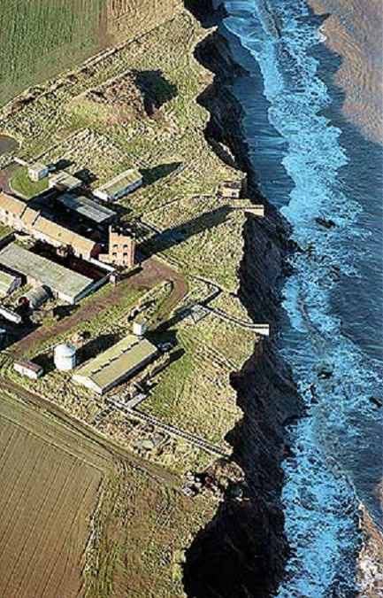
During the Second World War, the farm was chosen for the construction of an artillery battery. In recent decades, almost the entire military installation, including a brick-built observation tower, has succumbed to coastal erosion.
The land at Ringbrough is private property.

An RAF aerial photograph, taken in 1941 before the battery was built, shows the road from East Newton (left), south of Aldbrough, to Ringbrough Farm (right) as it follows old field boundaries in a zig-zag fashion. The frame represents about 1430 metres across [enlargement/attribution].

Traffic cones mark the former road to Ringbrough where it leaves East Newton. Until being lost to the sea, the road turned right beyond the field [17 September 2012].

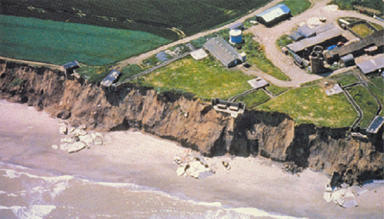
The last days of Ringbrough Farm. Built in the 1770s, and in 1833 standing 305 yards (279 metres) from the cliff, the farmhouse was required to be demolished before going over the edge [17 September 2011].

Site of Ringbrough Farm [15 July 2012].

Rubble from the farmhouse [15 July 2012].

Little is left standing at the cliff top [6 August 2016].
Below is a sketch map depicting the layout of Ringbrough Farm and Battery during the Second World War.
◀ smaller screens ▶


Toppled observation tower [5 May 2012].

From the cliff top [15 July 2012].

Lying on one side, partly in the sand, the tower is denied a sense of former bearing. In the manipulated image below, the structure has been righted and background removed. Proportions remain the same [5 May 2012].


All along the watchtower. The concrete look-out platforms, seen here from ‘above’, would have been fitted with metal hand-rails [15 July 2012].

Top end [15 July 2012].

Inside the upper section. The floor is on the right. A hatchway just visible at the far bottom right of the compartment as shown allows all-fours access to other sections [15 July 2012].

As above, rotated.

A smaller structure [5 May 2012].

Steps to nowhere [5 May 2012].

Gun mount [22 September 2014].

Remnants of Ringbrough [5 May 2012].

Like the medieval community before it, Ringbrough Battery is fallen to destruction and inevitable disappearance. In the case of the military defences, solid angular sections become wave-rounded blocks, are then reduced to stones and pebbles (washed south by longshore drift), and eventually erode to grains [5 May 2012].

View of the Ringbrough site from the lower beach. The tower is left of centre below the cliffs [5 May 2012].

This somewhat surreal sight of a bank of sandbags on the sand affords temporary cliff toe protection for the Aldbrough gas storage project [5 May 2012].

However, individual bags are plucked from the stack by the tide [5 May 2012].
The sandbags were later removed as part of the project’s programme.

A more recent type of tower now locates Ringbrough. Erected 700 metres out to sea, this one was used for taking in water to leach caverns within salt-bearing strata some 2000 metres beneath the surface, ready for the storage of gas. It is expected to be dismantled at a future date [5 May 2012].

Pipes from the leaching tower may be exposed during a reduction in beach level [29 March 2018].

Here, the formation of a gutter runnel leaves pipes suspended [29 August 2019].

Three pipes are visible in this picture taken from the foot of the cliff. The pipe on the left is 400mm outer diameter, used as a cable duct. The other two are each 500mm, one being a sea water intake and the other a brine return pipe [14 May 2022].
The pipes to and from the leaching tower are no longer used and are empty. Originally, the plan was to remove them after service but to do so could exacerbate cliff erosion and, at least for the present, they are to remain.

Back out at sea, the wreck of the Earl of Beaconsfield, a barque that ran aground 7 November 1887, may be seen at low tides [10 August 2017].
The wreck is at TA 27739 37527, or 53.818334, -0.061126054. It lies (±) 347 metres north-west of the leaching tower at a bearing of 296°.

Cliffs north of Ringbrough contain sands and gravels deposited in a series of outwash channels during glacial retreat. The small fall in the foreground occurred moments before the picture was taken [15 July 2012].

The land may make a defiant gesture to the sea but, in the battle of coastal erosion, the waves will always win [5 May 2012].
Content by Brian Williams unless otherwise stated.


