East Yorkshire coastal erosion
lacustrine deposit at
The Runnell, Holmpton

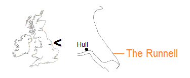
The Runnell is the name given to the mouth of Nevill’s Drain, a dyke that defines the boundary between the South East Holderness parishes of Hollym and Holmpton.
It is also the site of one of a number of lakes which, along with larger meres, were formed during the retreat of ice that covered and indeed created the land seaward of the Wolds line in East Yorkshire. Otherwise buried, the lacustrine deposit is exposed in the cliff as a result of coastal erosion.

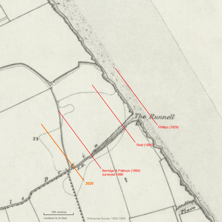
The Ordnance Survey map depicts the site at around the middle of the nineteenth century. A 25 feet (7.62 metres) contour indicates a depression in the land surface.
On the map, lines are added to represent the approximate position of the cliff around the dates shown. Three of the dates are those of publications of work in which the Runnell site was described according to observations made at the time, as extracted below. Pictures for the following slider gallery were taken along a line marking the cliff position in 2020.
go straight to gallery
Phillips, John (1829)
Illustrations of the Geology of Yorkshire, or a Description of the Strata and Organic Remains of the Yorkshire Coast
York: Thomas Wilson
We shall...proceed...to about opposite Holympton, where the cliffs are lower, and a more extended lacustrine deposit appears in a hollow of the diluvium. The length of this deposit is about two hundred yards [182.88 metres], and its extreme height above the sea, about ten feet [3.05 metres]. It rests in a hollow of the pebbly clay, which abounds along the shore, and consists, under the thin brown soil, of seven distinct layers of clay...The layers are thus arranged:
Lacustrine deposit. – Brown soil. Bluish bed of argillaceous marl. Shaly clay, changing upwards to white clay marl. Shaly bed of clay. Blue and brown clay marl. Black marl, with plant roots. Grey marl, with cyclades and paludinæ, which inhabited the lake. Diluvial clay, with pebbles of quartz, slate, and greenstone [pp61-62].
Reid, Clement (1885)
‘The geology of Holderness and the adjoining parts of Yorkshire and Lincolnshire’
Memoirs of the Geological Survey England and Wales
London: (printed for) HM Stationery Office
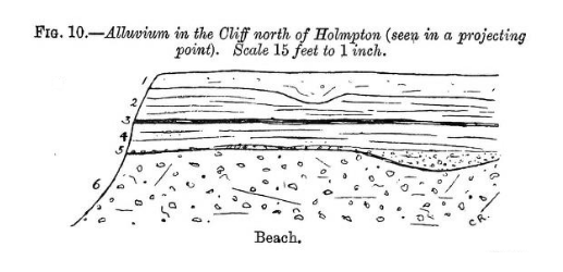
Two miles south of Withernsea, and not far from Holmpton, Nevill’s Drain flows into the sea, and for about 300 or 400 yards [274.32, 365.76 metres] the cliff is very low, seldom more than 10 feet [3.05 metres] above high water. This low portion is covered by alluvial deposits...The section (Fig. 10) was seen in a projecting point near the northern end of the basin.

1. Soil - 2 Feet [0.61 metres]
2. Loamy Alluvium - 3 Feet [0.91 metres]
3. Laminated peaty bed... 0½ Feet [0.15 metres]
4. Frest-water loam... 3 Feet [0.91 metres]
5. Gravelly soil, very irregular - 0½ Feet [0.15 metres]
6. Boulder ClayProfessor Phillips examined the same deposit in 1826, but the section he saw was so different from the one now visible...no measurements being given, it is impossible to say whether the lacustrine deposits thickened seaward [pp84-85].
Berridge, N G, and Pattison, J (1994)
‘Geology of the Country around Grimsby and Patrington’
Memoir of the British Geological Survey, Sheets 90, 91, 81 and 82 (England and Wales)
London: HMSO
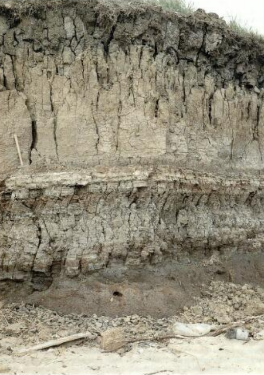
At The Runnell, a ‘mere’ depression 350 m long and 200 m wide is truncated by eroding coastal cliffs and shows lacustrine deposits up to 2.8 m thick (Plate 14). The following section was measured in 1986 (all beds tend to thin towards the mere edges, hence the thicknesses are maxima):
Thickness [in metres]
Silt, yellowish-brown; prismatic joints; gradational base 1.0
Silt, buff grading down to grey; laminated 0.7
Peat, silt and shell marl; interbedded and fissile 0.25
Silt, grey, laminated, with organic and ferruginous staining 0.6
Peat, laminated, silty (reworked) 0.2
Silt, grey, Shelly (local) 0 to 0.05
Clay, bluish grey, plastic, with some shells 0.2
Silt, yellowish-brown; prismatic joints; gradational base 1.0In places the basal clay is floored by traces of gravel, and the underlying Withernsea Till is locally bleached bluish grey to a depth of 5cm.

Plate 14 The Runnell, Holmpton
A low sea cliff cut through the centre of a postglacial mere deposit of Lacustrine Alluvium into underlying Withernsea Till. The older parts of the mere deposit, below the hammer head, are conspicuously rich in organic material, notably in a peaty layer near the base and in the prominent pale layer just below the hammer...20 June 1988 [61].
site visit 2 May 2024
The beach walk is south to north along a line from TA 36723 24631 to TA 36576 24820, a distance of 239 metres at a bearing of 322°. On the above OS map, the cliff line for 2020 is drawn to represent the length and relative position of the lacustrine deposit exposed at upper and middle cliff.
Pictures are taken at informal intervals, with minimal break of continuity. Beach level is low, revealing areas of clay platform.
Page prepared by Brian Williams in June 2024.