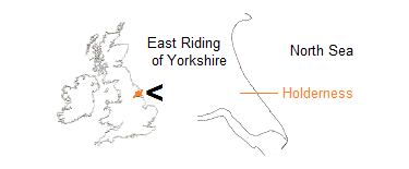
East Yorkshire coastal erosion
erosion in pictures

Waves approach the coast predominantly from a north-easterly direction and the water falls back under gravity at a lesser angle. As tides come and go, the sea can be thought of as sawing away at the cliff base. In stormy weather, there is also a destructive pounding.
.jpg)
Hornsea south: 17 September 2011.
.jpg)
Hornsea south: 17 September 2011.
.jpg)
Mappleton: 17 September 2011.
.jpg)
Skipsea south: 5 August 2011.
Where a cavity forms in the clay, a combination of surging water and trapped air may enlarge it to a temporary cave. Accumulations of pebbles and stones produce abrasive ‘milling’, which accelerates the process.
.jpg)
Skipsea south: 5 August 2011 (thanks to Margaret and Jean for providing scale).
.jpg)
Mappleton: 17 September 2011.
At the top of the cliff, the material of the edge has nothing to contain it on the seaward side. It becomes detached. Rainwater enters the clay more easily through cracks, weakening it further. Freezing in winter may cause expansion. Drying winds, especially easterlies, and summer sun result in shrinkage. Separation, or breaking off, of large pieces may continue in the cliff face.
.jpg)
Hilston: 17 September 2011.
A loss of material through wave action at the lower cliff leads to failure higher up. Entire sections of cliff are seen to slide, often with a backwards tilt (called a rotational slide). Pieces of the former land surface slowly descend the cliff as if on a downwards escalator. Elsewhere, the cliff may slump through the action of heavy rainfall.
.jpg)
Tunstall: 24 September 2011.
.jpg)
Hornsea south: 17 September 2011.
.jpg)
Hilston: 17 September 2011.
.jpg)
Hilston: 17 September 2011.
In some situations, part of the cliff face may crumble to fine pieces, or fracture along bedding planes. Generally, however, falls tend to be blocky, where occasionally a large amount of material is suddenly released towards or fully on to the beach.
.jpg)
Atwick: 5 August 2011.
.jpg)
Fraisthorpe: 15 September 2011.
Stack formation is rare in the Holderness clays although sometimes the potential is observed.
.jpg)
Easington: 15 October 2011.
The till of East Yorkshire is usually considered to begin at the north end, where the pre-glacial chalk cliff turns inland at Sewerby. There, clay also lies above the chalk where from time to time it slides or falls down the face.
.jpg)
Sewerby: 15 September 2011.
.jpg)
Sewerby: 15 September 2011.
Elsewhere along the coast, lengths of cliff break to a repeated pattern of indentation (sometimes called serration).
.jpg)
East Newton: 17 September 2011.
For a short depth below the surface, the clay is weathered into soil – this layer was once thought to be a separate till.
.jpg)
Sand le Mere: 24 September 2011.
There is contrast in angle of slope, also in height. A figure on the beach at the extreme right of the second picture below provides an idea of scale for Dimlington High Land, which rose even higher to the east in the past. Low cliffs are found at each end of the coast.
.jpg)
Easington north: 15 October 2011.
.jpg)
Dimlington High Land: 24 September 2011.
.jpg)
Fraisthorpe: 15 September 2011.
.jpg)
Kilnsea: 15 October 2011.
Heavy clay tills predominate, one member clearly overlying another in the cliffs to the south, but extensive sandy deposits can also be found in the cliffs.
.jpg)
Dimlington High Land: 24 September 2011.
.jpg)
Barmston: 15 September 2011.
As the cliffs erode, the sea tends quickly to break up and wash away the clay. Pictures taken of East Yorkshire beaches tend not to reflect the vast amount of material removed from the cliff. But mudballs will always be found somewhere. They may align parallel to the cliff or seem randomly scattered. A close-up of a mudball reveals a pebbly, ‘armoured’ surface, acquired from being rolled about by the tides.
.jpg)
Hilston: 17 September 2011.
.jpg)
Mappleton: 17 September 2011.
.jpg)
Atwick: 5 August 2011.
Another beach sight is the ord, a feature characterised by a sand bar, perhaps with shingle, and runnel (back channel). As ord systems migrate slowly southwards, they are associated with an increase in the rate of local cliff erosion.
.jpg)
Atwick: 5 August 2011.
Erratics of many sizes are found in the clay. A few exhibit flattened faces and parallel scratches, distinctive evidence of having been transported within a glacier.
.jpg)
Dimlington: 24 September 2011.
.jpg)
Withernsea south: 24 September 2011.
At certain locations, beds of silt, sand and gravel mark phases of glacial retreat, or boundaries between tills.
.jpg)
Sand le Mere: 24 September 2011.
.jpg)
Dimlington: 24 September 2011.
Some man-made structures found along the Holderness coastline were constructed to defend against enemy invasion. Anti-tank configurations now serve to mark the position of the cliff at the time of installation.
Defences to counter coastal erosion range from simple groynes, or breakwaters, to extensive sea walls. Gabions, which are metal enclosures filled with lumps of rock, have been used in places. Locations such as Mappleton and the gas terminal at Easington are protected by revetments of granite boulders.
.jpg)
Hornsea south: 17 September 2011.
.jpg)
Withernsea south: 24 September 2011.
.jpg)
Mappleton: 17 September 2011.
.jpg)
Easington: 15 October 2011.
Page prepared by Brian Williams in April 2012. Revised April 2019.