go straight to chart
This page follows on from a description of sediment segmentation on the beach movement page.
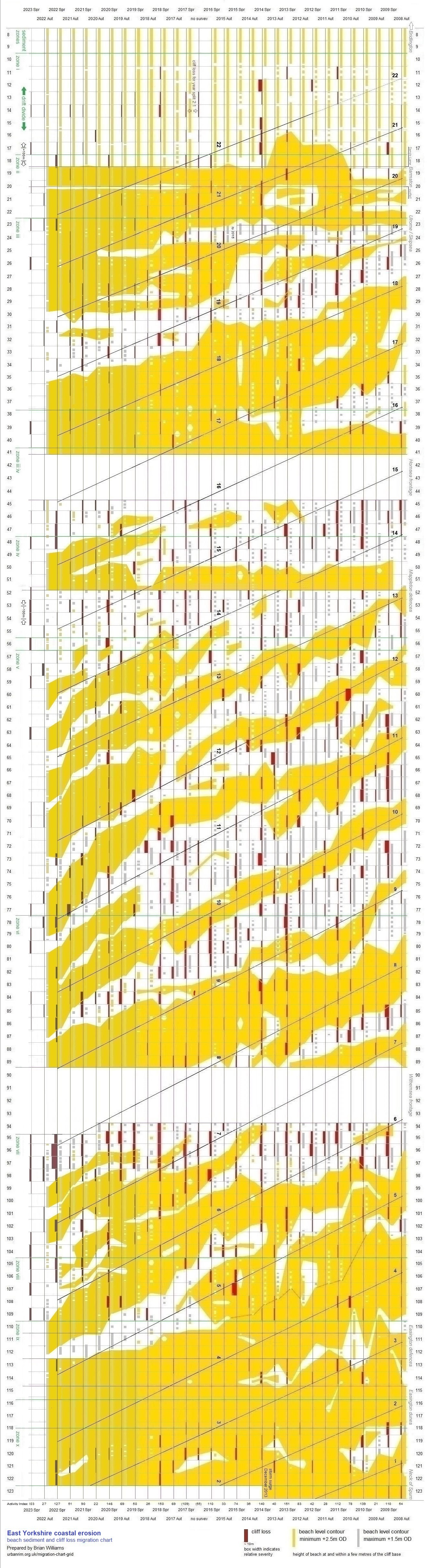
The period covered by the migration chart is currently twenty-nine erosion seasons, autumn and spring, beginning September 2008, the start of beach contour data, to October 2022 (cliff loss as at April 2023 added).
Data for autumn 2016 are absent as a result of adverse weather preventing a physical survey from being conducted. Measurements taken in spring 2017 were for a full year. In the chart the results are split 2:1 over two seasons.
All beach level contour and cliff loss data are supplied by East Riding of Yorkshire Council.
chart layout
The chart represents the East Riding of Yorkshire coastline from the south of the Bridington frontage. For convenience, the characteristic long ‘S’ outline is made schematically straight.
Numbers along the edges of the chart are those of monitoring profiles which, apart from two exceptions noted on the chart, intersect the coastline at intervals of 500 metres. Locations are listed at data summary and coordinates.
Compilation of the chart is right to left, to mimic east to west, the general direction of cliff recession. Each season, autumn or spring, is served by a column. Dates are shown at both ends of the chart.
cliff loss
Along the column for any one season, erosion in terms of land lost at the cliff top is displayed as a red box opposite the appropriate profile number. Width of the box indicates relative severity of the erosion. Actual values are available from data.
At the bottom of the chart is an activity index – the higher the number the greater the total cliff loss for the season.
beach sediment
Profiles 8 to 18
To the right of each column, a strip in gold-yellow depicts sections of full upper beach as surveyed at the profile location. A continuous length of colour signifies ample evidence of a full upper beach. Less well defined situations are given broken sequences.
Profiles 19 to 123
Strips in columns are run together in order to present an idea of the distribution of full upper beach deposits over seasons.
In the context of the migration chart, a full upper beach is regarded as lying within a contour minimum of +2.5 metres OD, extending for a few metres from the base of the cliff.
Sharing the same alignment as gold-yellow strips are strips in silver-grey. These show where the upper beach is low against the base of the cliff, contours having a maximum of +1.5 metres OD.
segments
Sediment segments or bodies are identified by numbered spines that cross the chart at angles.
A segment is represented on the chart by a full upper beach (gold-yellow), usually a salient. As a segment pulls across the natural beach, a depleted area forms behind it, which may include an ord system. The most acute sediment depletion appears on the chart in silver-grey.
Also shown, at the left of the chart, are sediment zones, employed for research purposes. The zones relate to potential variations in behaviour and characteristics as segments travel down the coast.
scroll
The migration chart image scrolls horizontally for all devices (bar at bottom).
Left/right/up/down arrows on the keyboard will scroll in steps.
Mouse alternatives are: Shift + wheel; press wheel or centre button and drag; push wheel to left and drag.
the migration chart
migration
According to the beach movement description, beach sediment starts a journey from within Bridlington Bay, to advance south along the Holderness coast to the Spurn peninsula, at the mouth of the Humber. Movement, driven by longshore drift, takes place in the form of a succession of segments.
In the chart, the process becomes apparent below Barmston. Bodies of sediment (in gold-yellow) are seen to work down the chart. Although configurations are subject to change, such as after the North Sea storm surge of December 2013, a certain ‘life course’ to sediment movement can be discerned.
Where major defence structures interrupt movement, sediment tends to accumulate on the updrift side and is reduced on the downdrift side. See the terminal groyne effect page.
Cliff loss (red boxes) migrates at a similar pace to the beach. For the period of the chart, about three-quarters of cliff loss is found opposite stretches lacking a full beach.
Some cliff loss, however, is seen in the chart to occur within the leading edge of a sediment mass. This may be due to delayed erosion, as follows.
direct and delayed erosion
During an erosion event, a depletion of beach sediment may bring about an entire collapse of the cliff, with loss of land at the cliff top which is captured in the erosion data for the same season. This could be considered direct erosion.
Alternatively, instead of full vertical failure, the cliff might be undercut or the base otherwise weakened. At the cliff top, there is no indication of removal of material below, and no retreat is recorded for that season.
After a while, acted on perhaps by a variety of processes (examples at erosion in pictures and cliffs), the degraded lower cliff is no longer able to support the weight above. Failure ensues, usually in the form of a slump or rotational slide. The resultant loss at the cliff top appears in data for a season later than that of the initial weakening, and therefore lags behind a beach situation that has moved on. This could be considered delayed erosion.
The two types are by no means mutually exclusive. A cliff possibly undergoes partial failure at the time of maximum wave exposure to become once more unstable as loosened material is removed, leading to a subsequent slump or slide. In such a case, cliff top recession at a particular location will appear in the data over two or more seasons.
Attempting to distinguish between the two types is a subjective exercise. Reference to the chart suggests that direct erosion may be twice as likely as indirect erosion.
cycles of cliff loss
A straight path projected horizontally across the migration chart especially within the area from Mappleton to Withernsea, where segments are well defined, will meet with distinctly separate spreads of gold-yellow. This is equivalent to someone at a single location perceiving that, over time, beach conditions and therefore incidences of erosion are repeated.
Cyclicity in cliff recession along the East Yorkshire coast is well noted. One long-held view is that material from a major collapse protects the cliff base for a time. The sea eventually removes the material, when the cliff is once more exposed to wave action.
Certainly the mechanism is to be seen, though on its own it does not account for an overall pattern to lateral movement of erosion. Also, cliff fall can be removed in a relatively short time, sometimes a matter of a few tides, rather than to the scale of years that separate cycles.
In a variation of the previous view, clay is washed away relatively quickly, but sandy material and boulders from the cliff remain on the beach for longer. Sand constitutes about a third of the coast’s glacial deposits, while stony content is abundant (the tills were once known as boulder clay). All are added to the local sediment budget to produce a rise in beach level. A higher beach absorbs some wave energy thereby decreasing the potential for cliff erosion.
Less cliff loss means a smaller contribution to the sediment budget. Beach level drops, allowing more wave contact with the cliff base. And so another cycle begins.
Again, the process does not explain patterns in migration. The stated source of sediment is important, but it is not the only one, and is arguably insuffient to influence changes in erosion activity to the extent observed.
forecasting erosion
It is possible by using the migration chart to forecast where and when – though not to what magnitude – erosion events and consequential loss at the cliff top are likely to occur.
‘Watchspots’, often hotspots, can be projected from the most recent surveys.
Profile locations are found at data summary and coordinates.
chart as image (1325x4850):
jpg (colour)
jpg (b/w)
png (colour)
png (b/w)
appendices:
sediment zones
beach levels and cliff loss (inc. sea level rise)
top
more on East Yorkshire coastal erosion
home
Page prepared by Brian Williams in February 2015. Last update September 2023.


